Administration
-
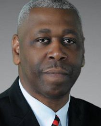
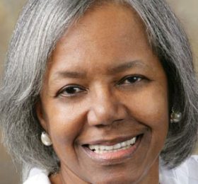
Hello citizens of Baker! My name is Darnell Waites, Mayor for the City of Baker. I am a retired army veteran that served our country for 27 years. I am married to wife April and have four children. I proudly accept the call to serve the citizens of Baker. As your Mayor I have several goals and aspirations for city and community improvements and economic growth for Baker.
In regards to economic development, my plan is to reduce and/or remove barriers for growth for our existing businesses, introduce incentives for new business in Baker and enhance major corridors. As your Mayor, I will strive to make city government and services more responsive, efficient, transparent and accountable. I will diligently work to improve property appeal by enforcing city codes relative to maintenance of both private and public properties and continue to make public safety top priority for our citizens. I am dedicated to being an honest mayor. As Mayor, the citizens of Baker concerns will be my concerns.
As this new administration moves forward, unity will be my main focus. Unity between all departments and the Mayor’s office and unity among the Mayor’s Office and City Council. It is only in a united fashion that we can move Baker forward. I look forward to “growing” with you.
-
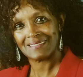
Beginning at the intersection of Mississippi Street and Baker Blvd., then east on Baker Blvd to its intersection with Debra Drive, then south on Debra Drive to its intersection with Jefferson Street, then east on Jefferson Street to its intersection with a road that is .23405 miles west of McHugh Road., then south on that road to its intersection with Brushy Bayou, then east on Brushy Bayou to its intersection with McHugh Road, then south on McHugh Road to its intersection with Groom Road, then east on Groom Road to its intersection with Shilo Street, then south on Shilo Street to its intersection with Kimberlin Drive, then east on Kimberlin Drive to its intersection with Buffet Street, then south on Buffet Street to its intersection with Fullerton Avenue, then west on Fullerton Avenue to its intersection with Shilo Street, then south on Shilo Street to its intersection with West Shilo Street, then west on West Shilo Street to its intersection with Sandra Drive, then north on Sandra Drive to its intersection with Harding Street, then west on Harding Street to its intersection with Daniels Street, then south on Daniels Street to its intersection with Coolidge Street, then west on Coolidge Street to its intersection with Daniels Street, then southwest on Daniels Street to its intersection with East Johnston Street, then north on East Johnston Street to its intersection with Coolidge Street, then west on Coolidge Street to its intersection with Myrtle Street, then south on and east on Myrtle Street to its intersection with East Buffwood Drive, then south on East Buffwood Drive to its intersection with Lavey Lane, then west on Lavey Lane to its intersection with the Illinois Central Railroad, then north on the railroad to its intersection with Coolidge Street, then east on Coolidge Street to its intersection with Epperson Street, then north on Epperson Street to its intersection with Buchanan Street, then east on Buchanan Street to its intersection with Myrtle Street, then north on Myrtle Street to its intersection with Groom Road, then east on Groom Road to its intersection with Johnston Street, then north on Johnston Street to its intersection with Jefferson Street, then west on Jefferson Street to its intersection with Mississippi Street, then north on Mississippi Street to its intersection with the point of beginning.
-
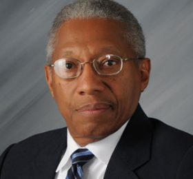
Beginning at the intersection of Groom Road and Plank Road, then east on Groom Road to its intersection with eastern corporate limit line of Baker, then following the corporate limit line of Baker in a clockwise direction to its intersection with Cypress Bayou, then southeast on Cypress Bayou to its intersection with Rafe Meyer Road, thence east on Rafe Meyer Road to its intersection with the Illinois Central Railroad, then north on the railroad to its intersection with Lavey Lane, then east on Lavey Lane to its intersection with Sinbad Street, then north on Sinbad Street to its intersection with Coolidge Street, then east on Coolidge Street to its intersection with Maureen Drive, then south on Maureen Drive to its intersection with Myrtle Street, then west on Myrtle Street to its intersection with Sandra Drive, then south on Sandra Drive to its intersection with Celeste Drive, then east and south on Celeste Drive to its intersection with Loflin Avenue, then west on Loflin Avenue to its intersection with Sandra Drive, then south on Sandra Drive to its intersection with Lavey Lane, then east on Lavey Lane to its intersection with Plank Road, then north on Plank Road to the point of beginning.
-
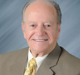
Beginning at the intersection of Highway 19 (Main Street) and Baker Blvd., then east on Baker Blvd. to its intersection with Mississippi Street, then south on Mississippi Street to its intersection with Jefferson Street, then east on Jefferson Street to its intersection with Johnston Street, then south on Johnston Street to its intersection with Groom Road, then west on Groom Road to its intersection with Myrtle Street, then south on Myrtle Street to its intersection with Buchanan Street, then west on Buchanan Street to its intersection with Epperson Street, then south on Epperson Street to its intersection with Coolidge Street, then west on Coolidge Street to its intersection with the Illinois Central Railroad, then south on the railroad to its intersection with Rafe Meyer Road, then west on Rafe Meyer Road to its intersection with Cypress Bayou, then northwest on Cypress Bayou to its intersection with the Baker corporate limit line, then following in a clockwise direction along the corporate limit line of Baker to its intersection with Highway 19 (Main Street), then south on Highway 19 (Main Street) to its intersection with the point of beginning.
-

Beginning at the intersection of Groom Road and Plank Road, then south on Plank Road to its intersection with East Myrtle, then west on East Myrtle to its intersection with Molino Drive, then north and west on Molino Drive to its intersection with Paola Street, then north on Paola Street to its intersection with Clermont Street, then northeast on Clermont Street to its intersection with Biscayne Street, then northwest on Biscayne Street to its intersection with Chipley Street, then north on Chipley Street to its intersection with Groom Road, then northwest and west on Groom Road to its intersection with McHugh Road, then north on McHugh Road to its intersection with Brushy Bayou, then west on Brushy Bayou to its intersection with a road that is .23405 miles west of McHugh Road, then north on that road to its intersection with Jefferson Street, then west on Jefferson Street to its intersection with Debra Street, then north on Debra Street to its intersection with Baker Blvd, then west on Baker Blvd to its intersection with Highway 19 (Main Street), then north on Highway 19 (Main Street) to its intersection with the north corporate limit line of Baker, then following in a clockwise direction along the corporate limit line of Baker to its intersection with Groom Road, then northwest on Groom Road to its intersection with the point of beginning.
-
Beginning at the intersection of Mississippi Street and Baker Blvd., then east on Baker Blvd to its intersection with Debra Drive, then south on Debra Drive to its intersection with Jefferson Street, then east on Jefferson Street to its intersection with a road that is .23405 miles west of McHugh Road., then south on that road to its intersection with Brushy Bayou, then east on Brushy Bayou to its intersection with McHugh Road, then south on McHugh Road to its intersection with Groom Road, then east on Groom Road to its intersection with Shilo Street, then south on Shilo Street to its intersection with Kimberlin Drive, then east on Kimberlin Drive to its intersection with Buffet Street, then south on Buffet Street to its intersection with Fullerton Avenue, then west on Fullerton Avenue to its intersection with Shilo Street, then south on Shilo Street to its intersection with West Shilo Street, then west on West Shilo Street to its intersection with Sandra Drive, then north on Sandra Drive to its intersection with Harding Street, then west on Harding Street to its intersection with Daniels Street, then south on Daniels Street to its intersection with Coolidge Street, then west on Coolidge Street to its intersection with Daniels Street, then southwest on Daniels Street to its intersection with East Johnston Street, then north on East Johnston Street to its intersection with Coolidge Street, then west on Coolidge Street to its intersection with Myrtle Street, then south on and east on Myrtle Street to its intersection with East Buffwood Drive, then south on East Buffwood Drive to its intersection with Lavey Lane, then west on Lavey Lane to its intersection with the Illinois Central Railroad, then north on the railroad to its intersection with Coolidge Street, then east on Coolidge Street to its intersection with Epperson Street, then north on Epperson Street to its intersection with Buchanan Street, then east on Buchanan Street to its intersection with Myrtle Street, then north on Myrtle Street to its intersection with Groom Road, then east on Groom Road to its intersection with Johnston Street, then north on Johnston Street to its intersection with Jefferson Street, then west on Jefferson Street to its intersection with Mississippi Street, then north on Mississippi Street to its intersection with the point of beginning.
